Navigational Technology Every Skipper Should Know in 2026
A New Standard of Seamanship in a Connected World
By 2026, the expectations placed on yacht skippers have advanced well beyond traditional seamanship, with stakeholders across the global yachting sector-owners, charter clients, insurers, and regulators-now assuming that any professional in command of a vessel will combine classic navigational skills with a high level of digital competence. From family cruisers in the Mediterranean and performance yachts racing off the coasts of Australia and the United States to superyachts operating global itineraries between Europe, Asia, and the Caribbean, the modern helm has become a sophisticated digital environment where navigation, communication, safety, and even onboard lifestyle systems intersect. For the editorial team at yacht-review.com, which has spent years conducting independent sea trials and yacht reviews across North America, Europe, Asia, and emerging markets in Africa and South America, this evolution has reinforced a central conclusion: the most trusted skippers in 2026 are those who not only know which technologies to use, but understand how they interact, where their vulnerabilities lie, and how to integrate them into a resilient navigational strategy that still respects the fundamentals of seamanship.
The line between "navigation electronics" and the rest of the yacht's infrastructure has effectively disappeared. Navigation data now informs propulsion management, energy efficiency, security, and guest experience, while shore connectivity enables real-time support from technical teams and management offices in regions as diverse as the United Kingdom, Germany, Singapore, and the United Arab Emirates. As a result, navigational technology has become a core leadership responsibility rather than a technical afterthought. Owners commissioning new builds or refits increasingly request integrated bridges, redundant communications, and advanced situational-awareness tools as standard, and the editorial perspective at yacht-review.com-shaped by its dedicated coverage of design and onboard systems-is that any skipper seeking long-term credibility in this environment must treat digital navigation as a strategic competency, continuously updated and rigorously practiced.
From Paper to Pixels: Electronic Charting as the Primary Reference
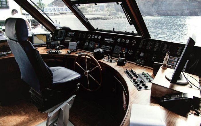
The long transition from paper charts to electronic navigation is now effectively complete in most advanced yachting markets, with paper retained primarily as a backup, a legal requirement in certain jurisdictions, or a deliberate training tool. In 2026, electronic chartplotters and dedicated navigation suites are the primary reference for the vast majority of skippers in the United States, United Kingdom, Canada, Australia, and across Europe and Asia. Multifunction displays from manufacturers such as Garmin, Raymarine, Simrad, and Furuno consolidate vector charts, radar overlays, AIS targets, depth and seabed information, and real-time weather layers into a unified interface that can be mirrored at multiple helm stations, including flybridges and remote wings.
The practical benefit of this convergence is undeniable: a skipper maneuvering in a crowded harbor in Italy, threading through coral passes in Thailand, or entering fog-bound channels off the coast of British Columbia can maintain a remarkably rich picture of the surrounding environment. Yet years of observation during yacht-review.com sea trials have made it clear that this sophistication also invites subtle risks. Over-reliance on a single display, failure to cross-check charted depths against the echo sounder, and blind trust in user-generated chart content can all undermine safety, particularly in areas where seabeds shift rapidly or hydrographic surveys are outdated. Providers such as Navionics and C-MAP have dramatically improved coverage for popular cruising regions, and crowd-sourced data has enhanced local knowledge in places from the Bahamas to the Aegean, but not all data is created equal, and prudent skippers treat the chartplotter as a powerful decision-support tool, not an infallible authority.
Understanding how electronic charts are produced and updated has become part of professional due diligence. Bodies such as the International Hydrographic Organization explain how official Electronic Navigational Charts are compiled and validated, and skippers who engage with such resources are better equipped to judge data quality and recognize anomalies when the displayed information does not match visual cues or depth readings. On the yachts most admired by the editorial team at yacht-review.com, the navigation station is designed with redundancy and ergonomics in mind: separate power feeds for key displays, clear sightlines, and the ability to navigate effectively from both interior and exterior helms, a design philosophy reflected repeatedly in the site's technology-focused coverage.
GNSS in 2026: Precision, Vulnerability, and Layered Redundancy
Global Navigation Satellite Systems-encompassing GPS, Galileo, GLONASS, and BeiDou-are now so deeply embedded in everyday life that many skippers scarcely notice how dependent their navigation has become on space-based signals. In 2026, multi-constellation receivers, augmented by SBAS corrections and increasingly by precise point positioning services, deliver exceptional accuracy even in coastal and high-traffic waters. Integration with autopilots, dynamic positioning systems, and advanced route planners allows for tight track-keeping, which is particularly valued by long-range cruisers transiting between continents and by captains maneuvering large yachts in confined marinas in France, Spain, the Netherlands, or the Middle East.
Yet the professional consensus remains consistent: GNSS is powerful but vulnerable. The U.S. Coast Guard Navigation Center and other national authorities have reported repeated instances of interference, jamming, and spoofing, especially in geopolitically sensitive regions, and anecdotal reports from skippers interviewed for yacht-review.com features in the Eastern Mediterranean and parts of Asia confirm that sudden position jumps or unexplained signal loss are more than theoretical risks. Responsible skippers now adopt a layered approach, combining primary receivers with independent backup units, handheld devices, and tablet-based navigation apps that can operate on separate power sources, while also maintaining traditional skills such as dead reckoning, visual pilotage, and compass-based fixes.
International bodies such as the International Maritime Organization continue to emphasize that electronic navigation must be supported by robust procedures and human oversight, and many training organizations have updated syllabi to include GNSS failure scenarios and resilience strategies. Skippers operating in heavily regulated waters, from Northern Europe to parts of Asia and North America, increasingly maintain written bridge procedures specifying how often positions are cross-checked, how discrepancies are investigated, and what constitutes a trigger for reverting to non-GNSS methods. In the experience of yacht-review.com, this disciplined approach is particularly evident among captains of larger yachts, whose owners and insurers expect a demonstrable commitment to redundancy and risk management.
Radar and Advanced Target Tracking: Essential in a Crowded Sea
Marine radar has undergone a quiet revolution over the past decade, with solid-state technology, Doppler processing, and advanced algorithms transforming what used to be a specialist tool into an accessible, energy-efficient, and highly informative sensor. In 2026, even mid-size cruising yachts in markets such as Germany, Sweden, Norway, and Canada often carry radar systems that can distinguish moving targets, highlight potential collision risks in color, and overlay returns directly on electronic charts. For skippers operating in fog-prone regions like the English Channel, the Pacific Northwest, or the South Korean and Japanese coasts, radar is no longer optional; it is an integral part of safe watchkeeping.
Automatic Radar Plotting Aid (ARPA) capabilities now come as standard on many systems, allowing automatic tracking of multiple targets, calculation of closest point of approach and time to closest point of approach, and clear visual cues for which vessels demand immediate attention. When combined with AIS overlays, a skipper in a busy traffic separation scheme off Singapore or Rotterdam can quickly distinguish between large commercial ships broadcasting AIS and smaller craft that do not, a distinction that often proves critical in poor visibility. However, sea trials and training sessions attended by the editorial team at yacht-review.com repeatedly show that the value of radar depends heavily on user competence. Incorrect gain settings, failure to manage sea and rain clutter, and misunderstanding of relative versus true motion displays remain common sources of confusion.
Training organizations such as the Royal Yachting Association and their counterparts in North America, Europe, and Asia continue to stress radar literacy as part of advanced skipper qualifications, and insurance underwriters increasingly look favorably on documented radar training when assessing risk for larger yachts. For readers considering upgrades or refits, the technology analysis on yacht-review.com frequently highlights how modern radar integrates with existing bridge systems, including practical insights from captains who have tested these solutions in demanding conditions from the Baltic to the Southern Ocean.
AIS and the Fully Connected Maritime Environment
The Automatic Identification System has matured from a commercial-shipping safety tool into a core element of yachting navigation and fleet management. By 2026, AIS Class B transceivers are ubiquitous on professionally operated yachts and increasingly common on private vessels in the United States, United Kingdom, Australia, New Zealand, and throughout Europe and Asia. Skippers rely on AIS to identify nearby vessels, obtain real-time information on their course, speed, and status, and open direct communication via VHF using precise call signs, which reduces ambiguity and supports proactive collision avoidance.
When integrated with chartplotters and radar, AIS information allows a skipper approaching a dense anchorage in the Balearics or a traffic-choked strait near Hong Kong to differentiate between fast-moving commercial ships, anchored vessels, ferries, and smaller craft. Shore-based and satellite AIS services, such as those discussed by MarineTraffic and other maritime data providers, now enable shore teams and family members to monitor yacht movements across oceans, a capability that has become standard for management companies overseeing fleets that operate between Europe, the Caribbean, the Pacific, and the Indian Ocean. Editorial features on yacht-review.com have documented how many captains now use historical AIS data to analyze traffic patterns, select safer routes, and identify less congested anchorages in busy regions such as the Amalfi Coast, the Greek islands, and the Florida Keys.
Nevertheless, AIS remains only one layer in a comprehensive safety strategy. Not all vessels broadcast AIS, equipment can fail, and data can be delayed or inaccurate. Experienced skippers maintain a disciplined visual lookout, use radar to detect non-AIS targets, and treat AIS primarily as a tool for early awareness and communication rather than as the sole basis for collision-avoidance decisions. This layered approach aligns with guidance from safety authorities worldwide and reflects the professional culture that yacht-review.com consistently encounters among captains of high-value yachts in markets from Monaco and London to Singapore and Sydney.
Integrated Bridges and the Digital Helm as a Strategic Asset
On many of the yachts profiled in the boats section of yacht-review.com, particularly in the 50-foot-plus segment and throughout the superyacht category, integrated bridge systems have become the norm. These solutions, developed by major marine electronics companies and specialized integrators, consolidate navigation, propulsion, alarms, monitoring, and communications into a coherent digital environment that can be configured for different operating modes, from coastal cruising to long-range passagemaking.
The operational advantages are significant. Data from engines, generators, fuel tanks, and stabilizers can be overlaid with navigational information, allowing the skipper to understand how route choices affect consumption, range, and comfort. Weather-routing recommendations can feed directly into autopilot settings, while security and CCTV feeds can be managed from the same consoles as navigation and communications. However, this level of integration also introduces complexity and the possibility of cascading failures if core network components or software layers malfunction. Captains interviewed for yacht-review.com features in the Mediterranean, Caribbean, and Asia-Pacific repeatedly emphasize the importance of robust redundancy, clear manual overrides, and the ability to revert to a "degraded but safe" operating mode if primary systems fail.
From a business perspective, integrated bridges are now regarded as strategic infrastructure rather than cosmetic upgrades. Owners and management firms in key markets such as the United States, United Kingdom, Germany, and Singapore increasingly view bridge specification as a board-level decision that affects safety, resale value, and operating efficiency. The business coverage on yacht-review.com has tracked how classification societies, insurers, and flag states are responding to this trend, often requiring documented training, maintenance logs, and software update records for vessels operating commercially or carrying significant numbers of guests. For skippers, mastering an integrated bridge means understanding data flows, network topology, alarm philosophies, and failover procedures-skills that go well beyond simply knowing which button to press.
Digital Passage Planning, Weather Routing, and Data-Driven Decisions
The last few years have seen a further refinement of digital passage-planning tools and weather-routing services, with higher-resolution models, improved ensemble forecasting, and better integration with onboard systems. Skippers planning Atlantic crossings, high-latitude expeditions to regions such as Svalbard or Patagonia, or seasonal relocations between the Mediterranean and the Caribbean now have access to sophisticated software that ingests wind, waves, currents, and climatology to propose optimized routes balancing safety, comfort, and fuel efficiency.
Meteorological authorities such as the National Oceanic and Atmospheric Administration and the UK Met Office continue to provide foundational data, including GRIB files, ocean current analyses, and long-range outlooks, which are then refined by specialized routing providers and onboard applications. The most experienced captains featured in yacht-review.com cruising stories describe a layered planning process: they consult professional routing services for complex passages, use dedicated software onboard for scenario testing, and then apply personal judgment based on vessel characteristics, guest expectations, and crew capabilities. The cruising section of yacht-review.com frequently showcases these real-world decision processes, from timing weather windows in the Southern Ocean to planning typhoon avoidance strategies in the Northwest Pacific.
Despite the sophistication of these tools, forecast uncertainty remains an inherent reality. Models can diverge, local effects can overwhelm large-scale predictions, and unexpected system developments can render a previously safe route marginal. Skippers who earn enduring trust from owners and charter clients are those who maintain clear contingency plans, identify alternative ports of refuge, define explicit criteria for delaying departure or altering course, and communicate these decisions clearly to all stakeholders. Technology, in this context, serves as a powerful enabler of informed, documented decision-making rather than a substitute for judgment.
Compliance, Safety Management, and the Regulatory Landscape
Regulatory expectations surrounding navigational technology have continued to tighten through 2026, particularly for yachts operating commercially or carrying substantial numbers of guests. Authorities in the European Union, the United States, the United Kingdom, and several Asian jurisdictions increasingly expect vessels above certain size or passenger thresholds to maintain up-to-date electronic charts, certified AIS and radar systems, reliable GMDSS-compliant communications, and documented safety-management procedures that explicitly address electronic navigation.
The International Maritime Organization and regional regulators have steadily refined standards for ECDIS, electronic logbooks, and bridge resource management, and while many rules are targeted at commercial shipping, they exert a strong influence on best practices in the large-yacht sector. The news coverage on yacht-review.com tracks these developments closely, highlighting how changes in reporting requirements, equipment standards, and training expectations affect skippers operating between Europe, North America, Asia, and emerging yachting hubs in Africa and South America.
In an incident or near miss, navigational technology becomes central to both emergency response and post-event analysis. Accurate position reporting, digital track histories, AIS logs, and radar recordings can all support search and rescue efforts and subsequent investigations. Integration with Global Maritime Distress and Safety System equipment and satellite communications platforms ensures that distress alerts and situational updates reach coordination centers quickly, an expectation that is now standard in regions such as the North Atlantic, the Mediterranean, and the busy sea lanes of East and Southeast Asia. Skippers who maintain their systems correctly, keep software updated, and ensure that crews are proficient in emergency procedures demonstrate the level of professionalism that owners and insurers increasingly demand.
Sustainability, Efficiency, and Environmentally Responsible Navigation
Sustainability has moved from the periphery to the center of strategic discussion in the yachting industry, and navigational technology is now recognized as a key enabler of lower-impact, more efficient operations. Route-optimization tools that minimize fuel burn, real-time current and wind data that support more efficient engine loading, and advanced monitoring systems that track emissions and energy use all contribute to reducing the environmental footprint of yachts across global cruising grounds.
For yacht-review.com, which maintains a dedicated sustainability section, the link between responsible navigation and environmental stewardship is now explicit. Electronic charts increasingly incorporate environmental overlays, including marine protected areas, no-anchoring zones, and seasonal restrictions designed to protect marine mammals and sensitive habitats. Organizations such as the International Union for Conservation of Nature and regional marine-park authorities provide data that can be integrated into onboard systems, allowing skippers to avoid restricted zones, select appropriate anchoring areas, and adjust speed profiles to reduce underwater noise in whale-migration corridors. Learn more about sustainable business practices in maritime and tourism sectors to understand how these expectations are shaping investment and operational decisions worldwide.
High-precision positioning and detailed seabed mapping also support more careful anchoring, reducing damage to coral reefs and seagrass meadows in popular destinations from the Caribbean and the South Pacific to Southeast Asia and the Mediterranean. In several jurisdictions, including parts of France, Spain, Italy, and Thailand, authorities are increasingly enforcing environmental regulations through AIS monitoring, patrols, and fines. Skippers who use navigational technology to demonstrate compliance and who communicate their environmental policies to guests and crews not only protect fragile ecosystems but also enhance the reputation of the vessels and brands they represent.
The Human Element: Training, Culture, and Continuous Learning
Amid all the technological progress, the enduring lesson from the global yachting community is that hardware and software are only as effective as the people who use them. The most respected skippers encountered by yacht-review.com during reviews, interviews, and events embody a culture of continuous learning, disciplined procedures, and open communication on the bridge. They treat new systems not as gadgets but as tools to be mastered, tested, and integrated into clear standard operating procedures.
Formal training remains essential. Advanced courses offered by national authorities, maritime academies, and recognized organizations now commonly include simulator-based exercises that replicate GNSS failures, radar clutter, AIS anomalies, and integrated-bridge malfunctions, often under time pressure and in congested virtual environments. In markets such as the United States, United Kingdom, Germany, Singapore, and the Nordic countries, owners and management companies increasingly require evidence of recurrent training and type-specific familiarization before entrusting skippers with high-value yachts. At the same time, informal knowledge-sharing through professional networks, industry gatherings, and trusted media has become equally important. The community and lifestyle coverage on yacht-review.com provides a platform where captains, crew, designers, and technologists exchange practical insights, lessons learned, and candid assessments of what works and what does not on the water.
Ultimately, the navigational technology every skipper should know in 2026 is best understood not as a checklist of devices, but as an integrated ecosystem of tools, data, and practices anchored by human expertise. The most capable skippers in the global yachting community-whether operating a family cruiser along the Canadian coast, a performance yacht in the Mediterranean, or a superyacht shuttling between Europe, Asia, Africa, and the Americas-combine deep familiarity with electronic charts, GNSS, radar, AIS, integrated bridges, and digital routing with humility, curiosity, and a commitment to ongoing improvement. This combination of technical mastery and professional mindset underpins the experience, expertise, authoritativeness, and trustworthiness that yacht-review.com seeks to highlight in its coverage.
For readers wishing to explore these topics in greater depth, the main portal at yacht-review.com and its dedicated sections on travel and destination cruising, global yachting trends, industry events, and onboard lifestyle offer an evolving, internationally informed resource that reflects the interests of a sophisticated audience spanning North America, Europe, Asia, Africa, and South America.